George Steck
A COMPANION VIDEO TO THE GLEN CANYON SERIES
<>~<>~<>~<>~<>~<>~<>~<>~<>

Prologue
The following missive is an actual account of George Steck’s rafting excursions that closely follows the movie embed (on YouTube) that was just posted as a companion diary. He called the movie Beauty Lost. George’s narrative is as genuine as it is informative. I later wrote a comprehensive tome on the movie, in three parts, and will include some of part 1 in this diary, which I dubbed “Before.” Its literary contribution is meant to add salient background to George’s excursion and therefore not intended to edit what he related in the film.
Let me begin by relating what he once told me about his coming here, and why he did. George was more of a hiker than a river rat. Thus he and the others in the group came here for two reasons:
- To raft Glen Canyon before all river traffic was deemed verboten by the government
- The explicit purpose of hiking into Glen Canyon’s backcountry from the river.
Otherwise, his other Glen Canyons hikes over the years (both before and after the dam) were from the rim country.

That being said, I have already mentioned all the relevant facts of Glen Canyon’s before, during and after phases, that is, in the previous five diaries. Hence, I will dispense with such background and get right into George’s excursion. For readers who have not yet read these previous posted missives, they can be accessed by going to my profile and locating the list of same, then clicking on the titles. Also, I want to mention, as an apology, that some of the photographs that initially appeared in the diaries have, well, disappeared. I recently discovered the mystery behind the removal of the photos: I stupidly deleted a folder of photographs that were used for some of the diaries. Thus all those photos matching that particular folder's archives (most of which were liberated from Google) likewise disappeared. How stupid of me, huh? So, I will relocate some of the photos and add them in the following account.
By the way, the answer to last week's Monument Valley posting about there being no river inside its border is those calvary and Indian chase scenes took place up the road a bit, there at Mexican Hat, on the San Juan River. The geologic backdrop is a dead giveaway in that both geologic settings are that remarkably different. Wa-ha, as the Duke might say!
::
The Movie Begins
George and Helen Steck had chartered a Cessna 182 from Albuquerque to Glen Canyon, using a primitive airstrip to land near Hite. That was the put-in for all rafting excursions, also the designated meet-up with four friends who were already assembled and waiting (including towing George’s trailer with the raft and all necessary camping supplies and equipment for the approximate two-week excursion. It was likely early April when the six friends embarked on their down-river odyssey. He told me the reason for their flying to meet the others was expressly meant to film Glen Canyon before the planned deluge (starting in the early 1960s).

Of course, he and the others were coming to this bucolic canyon frontier to see and experience these kind of places that would soon be flooded:

Thus, and up to that point, George had filmed the regional landscape from the airplane. Due to the age of the Technicolor film it made everything appear warm and synthesized. Indeed, whatever George panned from the front seat of the high-wing Cessna had captured a microcosm of the greater physiographic Colorado Plateau province in this sector of northeast Arizona and southeast Utah. It was an immense and illusory emptiness that usually defines a desert-canyon terrain common in most of the Southwest, only back then there was a conspicuous absence of population, industries of any kind, and a network of roads. Most an orangish or tan desert landscape punctuated by laccoliths (Navajo Mountain) and an array of buttes and mesas and lengthy plateaus on the horizon, like great ships sans sails and smokestacks. How wonderful! Because there were no coal-fired plants, like the Navajo and Four Corners power plants (respectively, Page and Shiprock) acuity was much cleaner and clearer than what later happened throughout this quadrant of the Colorado Plateau.

Although the silent movie lacked the sharper clarity and contrast of modern cameras, everything George focused on was realistic as it was atmospheric. The sandstone country backdrop represented the kind of cinematography reminiscent of a stage-set minus towns and people. The only props down there were typical landmark features rising from the floor of the Great Basin Desert that spread out in this sector.
After panning regional scenery en route to Glen Canyon, including the rounded dark mound of Navajo Mountain rising above Glen Canyon’s eastern ramparts, the Escalante and San Juan drainages appeared as gently curving and shadowed fissures cleaved into the level plain of the desert pavement. They were almost there. Although Page was a fledgling worker’s community at the time, George told us he intentionally avoided filming its layout. He didn’t even want to film the nearly finished Glen Canyon Dam Bridge (though it does show up at the end of the film) and the partial dam construction. Then the airplane banked and a closer view of Glen Canyon showed up on the screen. The canyon’s pale and continuous contour of terrain was brief, though telling (that is, in an historical sense of our watching what was long ago suffused by deep lake water). Next, the Colorado River appeared, its slightly serpentine channel tucked inside the canyon’s mid-center, showing up on the left side of the screen. Ensuing, the virtual flight's sensation took us directly to where the pilot was about to land. George pointed out the Hite Ferry (at North Wash, buoy marker 139). The primitive contraption floated across the smooth back of the river headed toward the Red Rock Plateau country. The next frames showed an unpaved landing strip that suddenly appeared as the Cessna descended, and seemingly losing a lot of altitude all at once.
The next splice was the Steck’s meeting their friends, Melvin and Lois Kerner; also the other two new members in the party, whose names George couldn’t remember. But he said they were friends of the Kerner’s and that made all of them friends who came to enjoy Glen Canyon’s better days before the final interment (his words). His lament, assuming that was the intent, sunk in. The single overriding notion that pushed back the despair we felt was the fact we were about to join George’s group for a down-river odyssey.

The scene that followed looked somewhat chaotic. The cumbersome-looking neoprene raft was loaded and the group prepared for their adventure. It was a dun-colored inflatable ten-man Navy assault landing craft intended for paddling. George mentioned he had acquired the beast (his term) from a friend for a couple hundred dollars. Because of its weight when loaded, he decided to mount a 7.5 horsepower dual-stroke outboard motor on the rear of the approximate 20-foot-long raft, but planned to use the engine only when and if needed. Otherwise, the 4 to 5 m.p.h. current would do most of the work. Since there were no services anywhere downstream, saving gas and conserving food and choice beverages was necessary. I assumed by choice he meant beer and wine, a typical preferred drink for rafters especially in hot, dry desert terrain. The next frame showed Marvin and his friend with short paddles in their hands. They would paddle the rig and George would help steer from the rear. A hand-pump was also a mandatory item of equipment stowed onboard. He explained the obvious: it was used to siphon excess water from the raft’s interior which George said was necessary on quite a few occasions.
Obviously, the beast was not self-bailing as are more popular design in the contemporary rafting world. Fully loaded with camping supplies, food, beverages, fresh water, and a tarpaulin to keep the gear and food dry, the six carefree passengers sat inside its somewhat cramped space and leisurely floated down the Colorado. George steered with one hand and panned the scenery with the other. Watching that joyful entourage it was almost to the point we could feel the blazing sun and dry mouth that’s common when rafting in the typical arid canyon country of the Southwest. Our idyll down the muddy lane of the Colorado was only minutes into the movie.

Rising from either side of the channel, burnished bluffs lined the way in golden sunlight. Compared to the the cramped view from the bottom of the Grand Canyon the elevation of Glen Canyon’s tiered formations was a modest height, though nonetheless impressive. The film highlighted sheer, upper reaches and made it appear the canyon got deeper at every turn of the river. George’s focus was obviously on the perspective. In places, indented panels hundreds of feet high graced the lower facade of formations nearly from base to summit. These so-called conchoidal fractures were like windows fit for a basilica, only made out of sandstone. All the mind had to do was fill in those tall, indented blanks with stained glass images of one’s preference (though I thought the great emptiness of each was a better representation). George mentioned these stenciled frames (called conchoidal fractures––see following photo) went on for about a mile in that sector.

Snakelike, the two-toned tongue of river slithered through the sun-splashed corridor and may have averaged about a hundred yards wide. I couldn’t decide if it was café au lait or caramel syrup that best described the tincture. True to George’s statement, there wasn’t so much as a decent-sized ripple in front of the raft and barely a wake behind. Seldom did the walls encroach on the main channel, which left plenty of sandy beaches on either side, whose material was deposited by the river that transported the broken down sediment. Because the water level was so low, either the spring runoff that year was already spent or still on its way.

Not too far downstream from Hite the depth of the canyon turned even more impressive as canyon walls rose even higher. Whittled and beveled by wind, water, and to some lesser degree, plants and roots of trees, the facade on either side of the river retreated, creating a wider interior. Here the rafters gawked at the passing view. Each seemed to be alone in his or her thoughts without a need to say anything to one another. The men were shirtless and wore shorts and the women sported two-piece bathing suits. All were hatless, except George: he wore a tattered straw hat.
Down the gently curving lane of unruffled and unhurried water the revelers floated. They made a stop for lunch and later enjoyed a brief hike before resuming the trip. George resumed filming the background: the brownish sheen of the river below the canyon walls reflected saffron-colored light, with six tanned or red-skinned bodies basking in the immediate foreground. Above, a blue sky hosted a smattering of itinerant clouds. The formations darkened as shadows briefly brushed across their surface.

Beaded light of an aged afternoon inclined downward, changing the attenuated puce-black shadows that marked a multitude of chasms. These side-canyon drainages grew away from the river and invited the hikers to enter and explore farther reaches leading into the canyon’s interior. After the hike they were back in the rafts and once more idle until the next stop and hike. George filmed the troupe, some of whom spontaneously hammed their scenes. The members of the group were festive and sometimes contemplative, depending on what each was thinking or doing at the time. Casual or giddy, the general summation given the heavy heat was one of unbridled joy without reserve.
They hiked in these kind of places. . .

Or here. . .

Their latest parodies and amusement over, George turned the camera back to the main feature: the backdrop of the canyon. Orange, pink and varying hues of brown, smooth-faced formations towered above the river’s corridor. Those compelling vistas still did most of the communicating and George, like Helen, was singularly pensive. Thus sparing on too much commentary. (It was as though both replayed their own private memories, just the way some people feel when perusing photographs from their more ancient past.)
In one scene that followed, a spout or clear, gushing funnels of water leaped out of a lateral drainage. I estimated the waterfalls was at least seventy-five feet in length. Then another similar view, this time a slender veil of water draped down and over a sharp edge of water-worn rock. George exclaimed how the falls, among other side stream sources, were potable, including the river that he compared to the color of a chocolate malt. But for that, he quipped, it was necessary to strain the water the night before, then let it sit overnight in a bucket. After settling, just pop in a fizzy or two and it was good to go (he meant drink). He added how the fizzy solution only slightly improved its pungent taste.

We were all amazed to hear this, because streams and rivers are prone to the dreaded giardia, which is a flagellated protozoan parasite that colonizes and reproduces in the small intestine. The net result of this long-lasting chronic problem is explosive diarrhea, among other chronic side effects. However, George said none of his group contracted anything harmful to the body.
At one point, George called out, “I know this place––Tapestry Wall!” (buoy marker 109-110) This popular location on the right side of the river earned the moniker because of the elegant staining caused by manganese and oxides. It was certainly among the world’s largest natural tapestry and entirely made out of sandstone. Someone in our group had asked if Major Powell had named most of Glen Canyon’s famous and documented places. George related that some of the names, like Music Temple, were named by the major, but many Glen Canyon haunts were designated by a contemporary group of canyon devotees who called themselves We Three: Tad Nichols, Katie Lee and Frank Wright. This venturesome trio of river rats were very familiar with Glen Canyon because they often came here for hiking and rafting. With respect to the U. S. Geological Survey conducted in the 1960s, most of the names that appeared on later maps of the hitherto terra incognito setting recorded the epithets designated by the trio, which also preserved a few select names mentioned by Major Powell and some few other famous Glen Canyon river runners or hikers.

Farther down the river huge rectangular-shaped blocks of rocks appeared high above the channel. These bulk remnants looked like cantilevered castles, each perched on top of steep talus slopes that once was a part of these very structures. Cleaved and honed by erosion, the oxidized fragments broken away from a greater mass were physical clues of nature’s impermanence. In short, nothing lives forever, not even the rocks. Glen Canyon, as an erosional template of nature, was surely deteriorating, yet at a million times slower than a snail’s pace; also, obviously breaking down in aesthetically pleasing ways such as this part of the movie displayed.
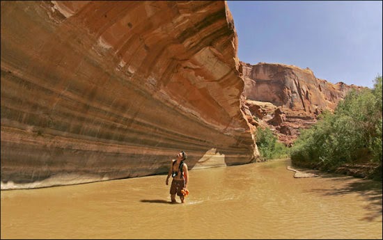
A hazel-colored panorama traded frames with a side canyon dark with time and painted with murky veils on the walls. Next, the water nymphs were on foot again, merrily sloshing up a partially shaded entryway. Their gait seemed more hurried than usual, as though they could hardly get to where they intended to go. The pathway soon turned into a winding maze and an impromptu venture was underway. George remarked many of those side canyon corridors they hiked into were so slender it was easy to touch both walls with outstretched arms; at least for George this was true since he was the tallest in the group. Hiking three, four or five miles each way was also common on these jaunts to the interior. Some of the thoroughfares had perennial water, and if there was generous sunshine during the day, he mentioned it was like wading through lukewarm bathwater. Because of ample water in most of the drainages, lush areas were widespread. The usual population of trees included tamarisk, box elder, redbud, willow, and of course the ubiquitous cottonwoods. Where the water wasn’t running, yucca, agave, cacti and other high desert plants anchored in the soil.

Here's another photograph of the Glen's interior and how embellished her canyon walls were in places. Notice the reflection of the adorned wall mirrored by the clear water:

Another similar frolicsome escapade showed up and the group was blithe and buoyant as usual. The farther they explored in this particular sector the water got deeper. He said most of the corridors selected for short or long hikes were ideal places to find archeological ruins. Some of the sites were built high into the face of steep inclines with pronounced overhangs. To gain entry, the ancient dwellers had constructed crude ladders out of piñon pine or cyprus (juniper) trees.

The high advantage obviously provided a good lookout, but also protected food supplies from rodents, and possibly from enemies. Most of the ruins were built on low or medium-height ledges. Some (like the above Glen Canyon ruin) were also concealed in nooks and crannies well off the beaten path. In these places, however, only a few people lived; possibly a shaman and others of his ilk, perhaps even his family. George mentioned one of the rewards when visiting any ruins was to find quizzical Indian rock art––pictographs. These graphic symbols of mostly human or animal figures were inscribed on textured walls and dated hundreds of years, perhaps much longer. Celestial or cryptic icons were also part of the primal nomenclature as varying symbols and shapes decorating walls and some larger rocks. Most images were duplicated throughout the canyon. Some of the symbols have meaning translated in today’s world, while others remain a mystery, and sometimes a conundrum.

Back in the raft again, the voyagers continued their obeisance still in the semblance of a leisurely down-river sightseeing quest. (But I thought of a quest for the legendary Holy Grail fable and how these providential six had already discovered the relic, though realized as an immense canyon habit connected by well over a hundred tendril side-canyons.) They drifted with the current like lethargic water bugs. As anticipated, I figured they were on their way to visit another destination on a preferred list. Some of these places someone in the group had also hiked to on previous occasions (George later mentioned this). En route to the next layover the scenery practically shouted for attention, with the group appreciably responding. Backlit by a late afternoon sun one entire face of a formation had turned assorted colors (mostly orangish and beige and a shiny bronze), with the river gleaming like molten amber. Thoroughly light-drenched at the upper reaches, some of the cliff facades appeared to perspire. George was busy with the camera and caught most of the light show that afternoon. That series of tableaus was nothing less than spellbinding.
New footage showed the group on another hiking promenade. This time they worked their way into a tight, twisting passage. The setting was utterly confining. Each side was riddled with hundreds of weathered indentations caused by wind erosion (a process called honeycomb weathering). These numerous pocked openings sheltered nesting cliff swallows and swifts, including the lyrical canyon wrens. Helen spoke up and mentioned it was quite melodious in places, and somewhat boisterous. The reverberation of sound in tight places like that is always a treat for hikers below. Occasionally, George turned the camera and spotlighted the group. Still cavalier and sanguine, they stood transfixed in a wide-opened sunnier locale, as though inebriated by the sallow light of the sun’s energy. From the muddy water to tan tiers of palisades, thence a pale blue atmosphere capping the backdrop, George wanted to record most of the canyon’s scenic motifs: light, color and form. Only sound and the sense of smell were missing. These perceptions we in the captive audience provided.

That particular sortie over, once more they were headed down river. At this point, George apologized for the seeming crude editing of the film, which he laughed and said he really never got around to doing it (editing). Instead, he had to frequently turn the camera on and off to preserve the batteries. Hence, the reason for not filming continuously.
Whenever and wherever rare sporadic riffles on the water showed up, and usually where a side stream entered the main channel, there was always time to play. One of the party floated by on an air mattress. He gestured with his arms and legs to express the intended burlesque of the scene. Often the group, either as a whole or individuals, acted like luxuriating children at recess.
George paused the film and said he and the others had the canyon all to themselves, for there were no boaters on the river and no hikers in the backcountry. He mentioned if there were commercial tour operators running the river they weren’t seen at any time during the trip, though they might have floated by when he and the others were hiking. None of us could imagine why more people in that era didn’t take advantage of the canyon’s isolation and its infrequent human traffic. Indeed, the water was so calm a child could captain a raft or a boat without any fear of danger. All that was needed was a life jacket to ensure safety on the water. Yet the Glen’s abode was never really popular with the masses. It seemed only a special clique of people ever came here, either to hike or raft. Thus this province was truly an out of the way setting that never attracted too many people other than those who appreciated a museum-like ambience of archeological ruins scattered throughout a less imposing canyon-haven.

Then the film resumed and it was time for another hike. At this locale, the group stood before a slightly curved wall, where a primitive ladder of Moqui (or “Moki”) steps were pecked into the sandstone. Made by earlier Basketmaker people or perhaps the later Ancestral Puebloans (formerly designated “Anasazi”), to scale heights more directly and quickly George pointed out the problem of using the ancient footings: primitive people who chiseled the crude stairway were much smaller in stature and therefore had feet that fit into the compact openings. His, however, were excessively large which made climbing and descending tricky, if not dangerous.

Following this sequence, George used some footage to capture the imperial views of higher domes, turrets, and some unnamed round-backed cap of rock that complimented the scenery. Islands of clouds were also in the picture, adding some bas-relief to the ashen dimension of the heavens.

George said there was no hopeful rain in their passing. The aridity and heat they endured on a daily basis was tangibly conveyed by that scene. Typically, it was always hot on the river, not a sticky hot the way humidity feels, but blast furnace hot especially when the heat was directly reflected from rocks. Temperatures ranged anywhere from 100 to 115 degrees except at night. Only then did it cool down to about 80 degrees. Other than an occasional breeze skimming up or down the main corridor the only relief was to plunge in the water, then float along on an air mattress or wade alongside the raft. In places, the water was shallow, perhaps two feet (or less), and often mudflats or sandbars turned up. When this happened, the raft had to be dragged to deeper water before resuming the voyage.

Naturally, George could not film at night. Still, there were some sequences of the group preparing for camping which he wanted to capture on the movie. Then Helen spoke up and said every night spent near the river listening to its song and serenaded by dozens of melodies contributed by birds and insects, was nothing less than a lulling berceuse. George chimed in and said the last rays of the sun had softened the light in one scene that he shot, and was like watching a curtain of shadows slowly rise up and cover the towering walls above their campsite. He mentioned that particular scene was something only the mind could preserve and treasure. He added how prolonged bleats of the tiny canyon tree frogs (Hylan arenicolor) with their booming voices merged with the gurgling from a nearby stream and merely enhanced the mood. George could sometimes wax poetic like that. These character may be little, but they have loud voices for calling back and forth to their lovers. . .

Following that footage was one series of frames that particularly caught my interest and came up on river right. Here the Escalante River melded its brown body with the Colorado’s nearly matching color. This drainage was a gorgeous microcosm of Glen Canyon. Flowing somewhere close to the juncture was Gregory Natural Bridge (buoy marker 68) and Cathedral in the Desert (in this same vicinity). This side canyon tributary was home to hundreds of archeological ruins, some with decorated panels of rock art. Though inviting, even tempting, George and the others decided the threatening weather that afternoon was reason enough not to venture too far up the river’s channel. Instead, they waded or swam for a while. . .
This is typical Escalante River country:
And so is this:

Afterward, they went back to the river and continued downstream, where more baronial vistas moved across the screen.

The next sequence was one of the more famous off-river attractions: Hole-in-the-Rock. At this historic location, Mormon pioneers traveling in covered (open) wagons somehow managed to do the impossible––an arduous trek across Glen Canyon that included fording the Colorado. Even more valiant was the fat they came down a precipitous incline––bag, baggage, and wagons. Horses, oxen, cattle came down separately as did the people. Once assembled at the bottom the next challenge was to cross the river. After the harrowing descent providence paid off, for an Escalante carpenter, Charles Hall, was hired to fashion a crude, though adequate, ferry to get the wagons on the other side as well as the people and their usually bawling livestock. And can you believe not a person, not an oxen or a horse, was injured or killed coming down this steep precipice? Well, it's true.

The movie resumed. Downstream from the famed Mormon crossing there was another hiking adventure the group enjoyed. This time, and in this unknown locale, there were places where the water was over their heads. There were also obstacles to overcome––large chock stones wedged between close canyon walls. These sectors required agile moves to get under or over the boulders. One of the men suddenly lost his grip on the slippery walls, then plunged into the water. Not too long after that footage George told us Helen had also slipped, but on a solid surface. The incident either broke an ankle or the injury was too swollen and sore to continue hiking. They were also too far from any town to evacuate her for medical help. Helen proved resourceful, however. George related how his dear undaunted wife was utterly pragmatic given the fix she was in: she came up with another solution and didn’t want to think of the trouble a rescue would entail. Her idea was to fashion a provisional cast of mud, and when dry it would more than suffice for plaster. Amazingly, the idea worked! George said she never even complained about the discomfort. (If the group had a medical kit, he didn’t mentioned it.) Later, and on another hike, Helen tripped again, only this time the sprain or break was somehow alleviated or the bone reset. She thought her hobbled circumstances was nothing less than a gift from the canyon gods. George, after sharing that story, looked over at Helen and said, “Now you see who the real hiker of this family is!”
Another layover, another hike, this time to the acclaimed Music Temple; at least George initially thought it was this historically significant setting. However, where he and the others ended up that day turned out to be Mystery Canyon (buoy marker 52), later renamed Anasazi Canyon, which was a few miles below Music Temple. Here's a somewhat distorted archive photo of Music Temple:

George then explained the real mystery was trying to figure out where the Moqui steps were in this location (Anasazi Canyon). A sequence of shots also showed the trim and athletic George climbing the side of a high, rounded wall, using a rope he had brought along for the occasion. (George later told me on other hikes he did finally make it Music Temple (buoy marker 43), as well as other significant locales, like Cathedral in the Desert (buoy marker 68), Cornerstone Canyon (buoy marker 40) and Mountain Sheep Canyon (buoy marker 44), formerly called False Entrance Canyon.) Of all the haunts in the canyon, this habitat 2.5 miles from the river is considered the most sublime: Cathedral in the Desert:

A profusion of rock art showed up at the next stop which George called Deer Creek. A few in the party appeared to study some intriguing handprints painted on the wall. There were also other drawings that depicted a long line of deer, followed by desert bighorn (sheep). Here's an example:

There was no buoy marker or designate on a map to confirm the location George had mentioned. But he might have meant Aztec Creek (buoy marker 49) or even Twilight Canyon (two miles further north), which was a well known setting for rock art.
The camera lens turned downward in the next sequence. This time George filmed a pattern of small stones on the ground. Together, the assembly formed the letters, Rainbow Bridge. Entering by way of Forbidding Canyon (buoy marker 49), George estimated it was a six-mile hike each way. Once there he and a few others scaled the U-shaped phenomenon straddling Bridge Creek. With a span of 275 feet, which recently was measured with a laser and downsized to 234 feet, Rainbow Bridge what the Navajos call “the rainbow turned to stone” (Nonnoshosh in their language). Regardless the new measurements, this natural bridge is still among the tallest and largest in the world, and certainly among the most awesome of similar spectacles. George remarked it was forty-two feet thick at the top and thirty-three feet wide, then stopped the projector and related a saga how the locale and bridge got its name. Although the Navajos and Paiutes knew about the bridge for many centuries, and possibly so did the Hopis, not until 1909 was this stupendous miracle-like creation publicized and made known to the public. However, trappers, mountain men and cowboys more than likely had set eyes on the impressive site many years earlier. In 1910, it was decided by the federal government to protect the sacred site claimed by various tribal nations by declaring it a national monument.

After the all-day excursion to see and climb the most famous symbolic natural bridge in the world (at least the highest in North America), the movie faded back to the river, this time featuring another tranquil view of Glen Canyon’s changing light and shadows. The magnitude of these images was implied in the perspective of the setting. Ensuing, a short hike into narrows leading to more ruins, more flowing water and still more plunge pools. It seemed there was always some special retreat to visit. Afterward, they were back on the river, headed for another sandy beach and campsite.
Once the evening settled George told us a gilded sunset highlighted by silhouettes was a befitting adieu to the day. Following this sequence, a creeping shadow mounted the wall just as the sun’s light faded somewhere beyond an unseen horizon. George commented how there was something animistic in that particular scene, and how filming the surreal lighting and noting the subtle changing colors was a treat to the senses. He even managed to film during the waning light of that particular spent day. But the movie camera could only do so much with its aperture, because the finale of a rarefied golden light primed itself and then turned a gorgeous crimson, as though the sky was on fire (which he was unable to record on film). That day’s safari was soon on its way to the accrued repository of esteemed memories and a fond farewell to Glen Canyon. He mentioned that, too.

The following day they made a stop at West Canyon Creek. They were getting closer to the takeout point. This time there was an unexpected and surprising encounter with a desert bighorn. The large ram seemed to stand and pose for George. What followed were dozens of running ewes apparently spooked by the strangers in their midst. The herd was most likely owned by a Navajo sheepherder who used that particular drainage for water and grazing. Usually dogs shadow the herd, but George joked the canine sentries probably waited at the other end because the herd had to eventually come out. Perhaps the sheep were even watched over from afar. . .

We knew the approximate thirty minute film was now about to finish for the background scenery was all too familiar, and suitable for a generic postcard: Padre Canyon and El Vado de los Padres––the famed Crossing of the Fathers (a/k/a “Padre Canyon” vicinity, now Padre Bay––around buoy marker 21). The legendary crossing is also formerly known as Ute Ford. Where Padres Escalante and Dominguez exited Glen Canyon in 1776, George and the others would exit some four miles down river, at Warm Creek, because the government’s mandated takeoff locale that year was not too far downstream from Padre Canyon. As previously mentioned, had not construction on the dam prevented further downstream travel, the original plan (from the year before, at least) was to float as far as Lees Ferry. To me, it was another irony of the evening: Glen Canyon could not save its estate anymore than George and the others would chance to run the block-aide set up by the Bureau of Reclamation sentries.
The two traveling frays crossed here, though this is today's Padre Bay look:

The movie was nearly at its end. George told is what it felt like to complete the trip, especially knowing the river would soon be closed to boat traffic. It was a long, hot and enjoyable vacation but it was time to go home. The group knew this part of the river and this canyon would not ever be the same, starting just a few years later (i.e., once the Colorado River backed up behind the dam). The summary of his statement came down to one word: pitiful. He stopped the movie at this point and mentioned some of the other places they had visited, but did not have enough film to record those sites.

The movie resumed, this time showing the guileless Colorado. I thought George’s intention was to pay his respects to this catalyst that first chiseled its way into the Four Corner’s mundane geography, eventually creating the sensation of this and other canyon settings. Strangely, the conspicuous Sentinel Rock (buoy marker 11), a giant monolith near the entrance of Wahweap Canyon, was not filmed. George didn’t say why, other than he reiterated it was simply time to get off the river.
The last feature in the movie was the lone sentinel, Gunsight Butte (buoy marker 17). George filmed its soaring landmark from the road, followed by a brief view of the steel-arch Glen Canyon Bridge. Near the structure was a glimpse of one of two diversion tunnels bored through the canyon wall and adjacent from the original river channel. The Colorado was temporarily still free. George said he did not particularly care to record the dam in its progress thus far. Before long, the river would also be forced into two diversion channels. Looking down at its deviated course from high above was a piteous site. It was indeed time for George and the others to return home. George did tell us that he came back several times to do more hiking in Glen Canyon, though he didn’t mention the dates or any specific places where he hiked. But that was the last rafting trip he took in the Glen.
This is Gunsight Butte today with a moat nearly surrounding its castle:

The view of the Colorado River exiting Glen Canyon faded on the screen and George stopped the movie. For a few moments he shared his thoughts about the dam construction in process and his nostalgic take on all the places he and the others had visited. After the spiel he turned the antique projector on again and this time the backdrop was filmed from George’s car (which one of the gathering had driven to Glen Canyon before the trip began). The Echo Cliffs’ tall-standing flank commanded the view. He then exclaimed in a blithe and kinetic tone, “And that’s it for Glen Canyon, folks. . . . bye!” It was time for us to reverse the time machine and return to the present.

Conclusion
In the original draft for my manuscript, Beauty Lost, I added more information about some of the scenery in George’s film, as well as geological and human and natural history. Thus the version just presented has been heavily edited. And a lot shorter.
As for George Steck, who left the earthly plane on April 13, 2004, he is no doubt hiking somewhere in the cosmos. His spirit may still be intact somewhere in this adopted territory he revered, the Southwest. He moved here in the 1950s, then stayed. I believe Helen departed a few years before and no doubt hikes with him. . . they were truly a devoted couple enjoying a long and happy and venturesome life.
For me, George’s timeless movie feels as though the space-time continuum reverses and remains dear to my heart. I also hope you have enjoyed the vicarious rafting excursion down Glen Canyon’s memory lane. Such adventure surely won’t come again until the dam comes down and the lake flows westward until empty. Then the Glen will reveal all of her comely features and Colorado River will return and no longer have its segments separated by some two hundred miles of deep basin water. And when do you think such an event is likely to come?
Meanwhile, here's to the Glen Canyon of yesterday and free-flowing Colorado through her interior:

And from this even better perspective:

As always, I look forward to reading and responding to your intelligent and thoughtful commentary (if you care to leave them).
Happy Trails!
Rich Holtzin
<>~<>~<>~<>~<>~<>~<>~<>~<>